WEEDON VILLAGE WALK
Length: 2 miles
The route is waymarked with specially designed Village Walk signs, designed by villager Martyn Allen.
Note that certain fields crossed by the route will have livestock at some times of the year. Take extra care and keep dogs on leads where this is the case.
For a printable pdf, please click here.
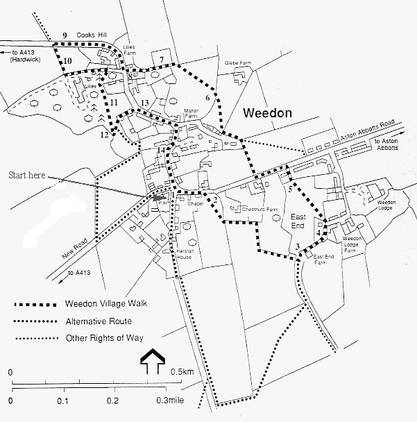
Start The Five Elms pub (HP22 4NL) at the crossroads. You can park along the road.
1 From the Five Elms, proceed along the road towards Aston Abbotts past the Methodist Chapel and Abbey Cottage. There is a kissing gate on your right by the field gate, about 50m from the chapel.
ALTERNATIVELY, head down Stockaway and follow the directions in (A) below.
2 Stand under the sycamore and enjoy the view ahead towards the Wendover Hills. Walk down the left hedgerow for about 150m and cross to the left through a double gate with wooden bridge into the next field. Lower down, the River Thame meanders along the valley, where it is named Thistle Brook.
3 At East End Farm, go through the kissing gate into the farmyard; then turn left and walk uphill along the concrete roadway.
4 The very old house on the right is a fine example of a long house, with five bays discernible. It dates from 1440. Pass through the gate on the left, and cross the field by the diagonal path. Note the ground contours indicating where houses existed in bygone days. At the top of the field, turn round for a last panoramic view to the south of the village.
5 Go through the gate up onto the road. Turn left and walk about 150m down the road, before crossing over to go through the kissing gate into a field. Note the typical undulations of medieval agriculture which are clearly evident. Take the gate at the bottom left into the back of Northcroft, then continue on through the pedestrian gate and down along the fenced-off section of path heading towards Glebe Farm.
6 Through the bottom gate, cross over Glebe Farm's driveway and up into Manor Fields vineyard, planted in the early 2000s. Go through the gate into the lower field of Manor Farm. Up to the left is the back of Manor Farmhouse dating from the 1600s. At the bottom of the field, turn left on to the Fortescue track.
7 The large field on the right was once allotments, left in trust to the Parish Council by Lord Fortescue and now let for grazing. The trust revenues are used to help villagers.
Creslow Brook flows from right to left along the valley, joining the River Thame after Quarrendon, and many argue that this is the true source of the Thame. Creslow and Thistle brooks, together with the lake at Watermead, provide an excellent habitat for wintering birds.
8 Up to the left as you meet the High Street are the remains of the village pump, with an arch of brick and stone, engraved 1877. Turn right and proceed down the part of High Street known locally as Cooks Hill.
9 There is a wonderful view of Hardwick village with its church up on the hill to the right. And look at the field in front for what are probably old earthworks.
The Aylesbury Ring Circular Walk is signposted to the right towards Hardwick, but the Village Walk turns left through a gate into a woodland area leading to Lilies.
10 The wood apparently boasts 43 different varieties of wildflowers, with wild garlic in profusion in spring. Snowdrops, violets, bluebells and the like have wonderful displays at different times of the year.
The kissing gate at the top of the path gives access to Lilies estate, but the public footpath turns left, back towards the village. In about 150m, go through the gap in the wall on the right, up the steps on to a path leading to old asphalt walkways. Lined with horse chestnut trees, they were laid as a convenience for workers at Lilies house.
11 Fernleaf and copper beech, together with new elms, appear with other distinctive trees, some planted by famous people like Robert Browning and Charles Dickens.
12 Two sequoia trees stand at the exit from this area. Before turning left, back towards the village again, look to the right over the gate at the fields used for the Bucks Show.
Now turn round and walk down the gravel roadway, through the gate by the thatched cottage Tumbling Acre, back into the High Street. Turn right.
ALTERNATIVELY, cross over the roadway into another wooded area – see (B) below.
13 On your left is the Wheatsheaf, formerly a public house, dating from the 15th century. A chevron can be seen in the brickwork. Follow the High Street up and round to the right past the front of Manor Farmhouse.
14 On the right is the Old Schoolroom, now the village hall, built by Henry Cazenove for the village in 1870. In the brickwork, you can see grooves made by pupils sharpening their slate pencils.
Carry on back up to the Five Elms crossroads, where you started (1). In front of you is Stockaway, now a dead end, but formerly the start of the old road to Aylesbury.
ADDITIONS AND ALTERNATIVES
A It’s just a quick 100m walk to the village pond with its white Aylesbury ducks, as well as mallards and moorhens.
For an additional loop, carry on down Stockaway into the fields, coursing round to the left following the paths to join up with the main route at East End Farm (3).
B From (12), follow the paths through a wooded wild area, out into a path that skirts along the edge of the Bucks Show fields, to meet New Road. Turn left up to the crossroads at (1).